Extensive questioning by local intervenor Kelly Izzard and others led to a new map and changes to the proposed Northern Gateway pipeline.
It was Izzard’s original questioning of Northern Gateway engineers which resulted in the creation of a new map showing the potential for a full-bore rupture of the pipeline at the pumping station to reach Stuart Lake, (published in the Caledonia Courier on Oct. 10).
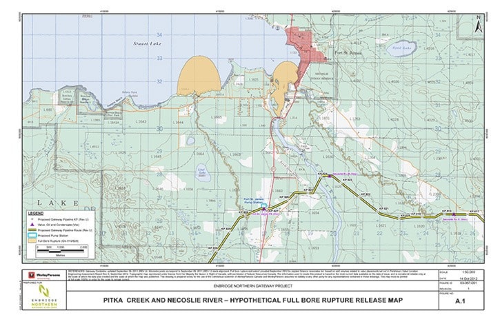
In the original project application, a map showing a hypothetical full bore rupture of the pipeline near the pumping station stopped before it showed where Pitka Creek reached Stuart Lake.
The Fort St. James Sustainability Group then asked about the map as part of the Northern Gateway Project Joint Review Panel process currently underway which the pipeline must undergo to obtain federal approval. In their response to the information request, Enbridge said the spill would not reach Stuart Lake.
“Based on the Northern Gateway’s spill modelling of a full-bore rupture release from the oil pipeline … a worst case scenario spill into Pitka Creek would not extend into Stuart Lake,” was stated in the written response given to the group’s information request.
Izzard then followed up on the map, questioning Enbridge representatives at a public meeting the company held in 2011, and again followed up with them early this year.
The questioning of the first application map resulted in the second map, which showed the potential for a full-bore rupture of the pipeline to indeed reach Stuart Lake via Pitka Creek.
The fact the original map did not even show Stuart Lake does not sit well with Izzard, and he is frustrated he had to raise the issue before the company came out with a more accurate depiction of a spill into Pitka Creek.
“They didn’t look beyond the neat line of the one to 25,000 scale map,” said Izzard. “It’s a long, convoluted story, but it speaks to transparency and understanding local people’s concerns.”
There’s no new information here except that they’re showing what, for whatever reason, they chose not to show.”
On Oct. 29, Kandace Kerr of the Fort St. James Sustainability Group in the Prince George hearings for the Joint Review Panel asked Northern Gateway why there have not been any changes to Enbridge’s spill response outlined in the application and if more work was being done to modify spill response, given a spill could reach Stuart Lake according to this new map. Northern Gateway Engineer Ray Doering’s response was contradictory to what the information request had stated previously.
“Ms. Kerr, I think you said initially we indicated a spill would not enter Stuart Lake, that’s not the case. We provided a set of maps in a response to a request for additional information from the Joint Review Panel (JRP) at a particular scale of map and so it’s provided a certain coverage. It didn’t indicate at all that there would not be a spill into the Stuart Lake. The map extent didn’t go that far and that was based on the parameters established by the question initially introduced by the JRP itself,” said Doering during the hearings.
Doering did, however, give Izzard credit for the information and questions he and others were bringing forward to the pipeline proponents and the changes which have since been implemented.
“Really this is another example of our ongoing engagement … we’re very interested in hearing from communities and -- and what their concerns are … I’d say as a result of discussions - specifically with you Mr. Izzard and with others along the route -that’s really helped us get to where we are now,” said Doering.
It was as a result of local concerns and because of the focus of questioning on the impacts the pipeline could have on the area around Pitka Creek, Stuart River and others, more shutoff valves have been added to the design of the pipeline, and the pump station would be manned instead of only being remotely monitored.
There will now be shutoff valves at a tributary to the Necoslie River, at the Necoslie River itself, between the Necoslie River and Stuart River and at the proposed Fort St. James pump station.
The additional valves would reduce the maximum full bore rupture volume of oil which could potentially be released from over 5,000 cubic metres to around 2,300 cubic metres, according to Doering.
However, this is still above the stated guideline from Doering which is to get below 2,000 cubic metres maximum release volumes where there are sensitive or important water courses.
But even with the additional valves, a full bore rupture still shows the potential for oil to reach Stuart Lake and Stuart River (see above).
The newest map was the result of Izzard’s questioning at the Prince George hearings when he was pressing Northern Gateway to look at the potential consequence of a full bore rupture into the Necoslie River.
Izzard said he still considers the risk too great, because on the latest map Northern Gateway has produced, a spill on either the Necoslie River or Pitka Creek still has the potential to reach Stuart Lake and Stuart River.
Related stories: